The Blue Marble, a photograph of the planet Earth made on 7 December 1972 by the crew of the Apollo 17 spacecraft.
The world is the totality of entities, the whole of reality, or everything that exists. The nature of the world has been conceptualized differently in different fields. Some conceptions see the world as unique while others talk of a "plurality of worlds". Some treat the world as one simple object while others analyze the world as a complex made up of parts.
In scientific cosmology, the world or universe is commonly defined as "[t]he totality of all space and time; all that is, has been, and will be". Theories of modality talk of possible worlds as complete and consistent ways how things could have been. Phenomenology, starting from the horizon of co-given objects present in the periphery of every experience, defines the world as the biggest horizon or the "horizon of all horizons". In philosophy of mind, the world is contrasted with the mind as that which is represented by the mind. Theology conceptualizes the world in relation to God, for example, as God's creation, as identical to God or as the two being interdependent. In religions, there is a tendency to downgrade the material or sensory world in favor of a spiritual world to be sought through religious practice. A comprehensive representation of the world and our place in it, as is found in religions, is known as a worldview. Cosmogony is the field that studies the origin or creation of the world while eschatology refers to the science or doctrine of the last things or of the end of the world.
The Mercator world map of 1569 is titled Nova et Aucta Orbis Terrae Descriptio ad Usum Navigantium Emendate Accommodata (Renaissance Latin for "New and more complete representation of the terrestrial globe properly adapted for use in navigation"). The title shows that Gerardus Mercator aimed to present contemporary knowledge of the geography of the world and at the same time 'correct' the chart to be more useful to sailors. This 'correction', whereby constant bearing sailing courses on the sphere (rhumb lines) are mapped to straight lines on the plane map, characterizes the Mercator projection. While the map's geography has been superseded by modern knowledge, its projection proved to be one of the most significant advances in the history of cartography, inspiring the 19th century map historian Adolf Nordenskiöld to write "The master of Rupelmonde stands unsurpassed in the history of cartography since the time of Ptolemy." The projection heralded a new era in the evolution of navigation maps and charts and it is still their basis.The map is inscribed with a great deal of text. The framed map legends (or cartouches) cover a wide variety of topics: a dedication to his patron and a copyright statement; discussions of rhumb lines; great circles and distances; comments on some of the major rivers; accounts of fictitious geography of the north pole and the southern continent. The full Latin texts and English translations of all the legends are given below. Other minor texts are sprinkled about the map. They cover such topics as the magnetic poles, the prime meridian, navigational features, minor geographical details, the voyages of discovery and myths of giants and cannibals. These minor texts are also given below. (Full article...)
Image 2
Race participants in Baltimore Inner Harbor, 2006 The Ocean Race is a yacht race around the world, held every three or four years since 1973. Originally named the Whitbread Round the World Race after its initiating sponsor, British brewing company Whitbread, in 2001 it became the Volvo Ocean Race after Swedish automobile manufacturer Volvo took up the sponsorship, and in 2019 it was renamed The Ocean Race
Each of the entries has a sailing crew who race day and night for more than 20 days at a time on some of the legs. Since the 2008–2009 race there has also been a dedicated media crew member called the On Board Reporter (OBR), who does not contribute to the sailing of the boat, but is responsible for sending images and video to race headquarters via satellite from the middle of the ocean. In the 2017–2018 race, the number of crew ranged between 7 and 10 (plus the OBR) depending on the gender ratio, with the rules providing an incentive to having women sailors on board. (Full article...)
The origins of the Internet date back to research to enable time-sharing of computer resources and the development of packet switching in the 1960s. The set of rules (communication protocols) to enable internetworking on the Internet arose from research and development commissioned in the 1970s by the Defense Advanced Research Projects Agency (DARPA) of the United States Department of Defense in collaboration with universities and researchers across the United States and in the United Kingdom and France. The ARPANET initially served as a backbone for the interconnection of regional academic and military networks in the United States to enable resource sharing. The funding of the National Science Foundation Network as a new backbone in the 1980s, as well as private funding for other commercial extensions, encouraged worldwide participation in the development of new networking technologies and the merger of many networks using DARPA's Internet protocol suite. The linking of commercial networks and enterprises by the early 1990s, as well as the advent of the World Wide Web, marked the beginning of the transition to the modern Internet, and generated a sustained exponential growth as generations of institutional, personal, and mobilecomputers were connected to the network. Although the Internet was widely used by academia in the 1980s, the subsequent commercialization in the 1990s and beyond incorporated its services and technologies into virtually every aspect of modern life. (Full article...)
Mercator was a notable maker of globes and scientific instruments. In addition, he had interests in theology, philosophy, history, mathematics and geomagnetism. He was also an accomplished engraver and calligrapher. Unlike other great scholars of the age, he travelled little and his knowledge of geography came from his library of over a thousand books and maps, from his visitors and from his vast correspondence (in six languages) with other scholars, statesmen, travellers, merchants and seamen. Mercator's early maps were in large formats suitable for wall mounting but in the second half of his life, he produced over 100 new regional maps in a smaller format suitable for binding into his Atlas of 1595. This was the first appearance of the word Atlas in reference to a book of maps. However, Mercator used it as a neologism for a treatise (Cosmologia) on the creation, history and description of the universe, not simply a collection of maps. He chose the word as a commemoration of the Titan Atlas, "King of Mauretania", whom he considered to be the first great geographer. (Full article...)
Image 5
The World Heritage emblem, used to identify properties protected by the World Heritage ConventionWorld Heritage Sites are landmarks and areas with legal protection by an international convention administered by UNESCO for having cultural, historical, or scientific significance. The sites are judged to contain "cultural and natural heritage around the world considered to be of outstanding value to humanity".To be selected, a World Heritage Site is nominated by their host country and determined by the international committee to be a unique landmark which is geographically and historically identifiable and having a special cultural or physical significance. For example, World Heritage Sites might be ancient ruins or historical structures, buildings, cities, deserts, forests, islands, lakes, monuments, mountains or wilderness areas. (Full article...)
Image 6
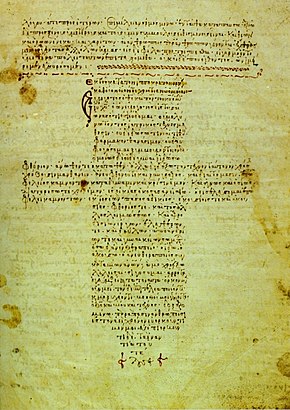
A 12th-century manuscript of the Hippocratic Oath in Greek, one of the most famous aspects of classical medicine that carried into later eras
The history of medicine is both a study of medicine throughout history as well as a multidisciplinary field of study that seeks to explore and understand medical practices, both past and present, throughout human societies.
The history of medicine is the study and documentation of the evolution of medical treatments, practices, and knowledge over time. Medical historians often draw from other humanities fields of study including economics, health sciences, sociology, and politics to better understand the institutions, practices, people, professions, and social systems that have shaped medicine. When a period which predates or lacks written sources regarding medicine, information is instead drawn from archaeological sources. This field tracks the evolution of human societies' approach to health, illness, and injury ranging from prehistory to the modern day, the events that shape these approaches, and their impact on populations. (Full article...)
The following are images from various world-related articles on Wikipedia.
Image 1Earth's night-side upper atmosphere appearing from the bottom as bands of afterglow illuminating the troposphere in orange with silhouettes of clouds, and the stratosphere in white and blue. Next the mesosphere (pink area) extends to the orange and faintly green line of the lowest airglow, at about one hundred kilometers at the edge of space and the lower edge of the thermosphere (invisible). Continuing with green and red bands of aurorae stretching over several hundred kilometers. (from Earth)
Image 2A 2012 artistic impression of the early Solar System's protoplanetary disk from which Earth and other Solar System bodies were formed (from Earth)
Image 3Artist's impression of a Hadean landscape with the relatively newly formed Moon still looming closely over Earth and both bodies sustaining strong volcanism. (from History of Earth)
Image 10Artist's impression of Earth during the later Archean, the largely cooled planetary crust and water-rich barren surface, marked by volcanoes and continents, features already roundmicrobialites. The Moon, still orbiting Earth much closer than today and still dominating Earth's sky, produced strong tides. (from History of Earth)
Image 11A view of Earth with its global ocean and cloud cover, which dominate Earth's surface and hydrosphere; at Earth's polar regions, its hydrosphere forms larger areas of ice cover. (from Earth)
Image 13An artist's impression of ice age Earth at glacial maximum. (from History of Earth)
Image 14The replicator in virtually all known life is deoxyribonucleic acid. DNA is far more complex than the original replicator and its replication systems are highly elaborate. (from History of Earth)
Image 15Tiktaalik, a fish with limb-like fins and a predecessor of tetrapods. Reconstruction from fossils about 375 million years old. (from History of Earth)
Image 16Chloroplasts in the cells of a moss (from History of Earth)
Image 17Trilobites first appeared during the Cambrian period and were among the most widespread and diverse groups of Paleozoic organisms. (from History of Earth)
Image 21A reconstruction of Pannotia (550 Ma). (from History of Earth)
Image 22An artist's impression of the Archean, the eon after Earth's formation, featuring round stromatolites, which are early oxygen-producing forms of life from billions of years ago. After the Late Heavy Bombardment, Earth's crust had cooled, its water-rich barren surface is marked by continents and volcanoes, with the Moon still orbiting Earth half as far as it is today, appearing 2.8 times larger and producing strong tides. (from Earth)
Image 25Change in average surface air temperature and drivers for that change. Human activity has caused increased temperatures, with natural forces adding some variability. (from Earth)
Image 26Pillar erected by India's Maurya Emperor Ashoka
Image 27Geologic map of North America, color-coded by age. From most recent to oldest, age is indicated by yellow, green, blue, and red. The reds and pinks indicate rock from the Archean.
Image 28An animation of the changing density of productive vegetation on land (low in brown; heavy in dark green) and phytoplankton at the ocean surface (low in purple; high in yellow) (from Earth)
Image 30Exaggerated illustration of Earth's elliptical orbit around the Sun, marking that the orbital extreme points (apoapsis and periapsis) are not the same as the four seasonal extreme points, the equinox and solstice (from Earth)
Image 31Conjectured illustration of the scorched Earth after the Sun has entered the red giant phase, about 5–7 billion years from now (from Earth)
Image 78Earth's western hemisphere showing topography relative to Earth's center instead of to mean sea level, as in common topographic maps (from Earth)
Image 80Angkor Wat temple complex, Cambodia, early 12th century
Image 81Pangaea was a supercontinent that existed from about 300 to 180 Ma. The outlines of the modern continents and other landmasses are indicated on this map. (from History of Earth)
Shenzhen roughly follows the administrative boundaries of Bao'an County, which was established in imperial times. The southern portion of Bao'an County became part of British Hong Kong after the Opium Wars, while the village of Shenzhen was on the border. Shenzhen railway station was the last stop on the mainland Chinese section of the Kowloon–Canton Railway, and Shenzhen's economy grew and it became a city by 1979. (Full article...)
... that Group A of the 2006 FIFA World Cup featured the highest-scoring opening game in World Cup history since the competition began using a single match opening format?
Grenada consists of the island of Grenada itself, two smaller islands, Carriacou and Petite Martinique, and several small islands which lie to the north of the main island and are a part of the Grenadines. Its size is 348.5 square kilometres (134.6 sq mi), with an estimated population of 124,523 in July 2021. Its capital is St. George's. Grenada is also known as the "Island of Spice" due to its production of nutmeg and mace crops. (Full article...)
The Seven Wonders of Portugal (Portuguese: Sete Maravilhas de Portugal) is a list of cultural wonders located in Portugal. The creation of the list was supported by the Ministry of Culture and organized by the companies Y&R Brands S.A. and Realizar S.A.
The total area of Georgia's protected terrestrial territories is 6,501 km2 (2,510 sq mi), which amounts to approximately 9.29% of the country's territory. In addition 153 km2 (59 sq mi) of marine area protected, or 0.67% of the country's territorial waters. There are a total of 89 protected areas, including 14 Strict Nature Reserves, 12 National Parks, 20 Managed Nature Reserves, 40 Natural Monuments, 2 Ramsar sites and 1 Protected Landscape. Strict nature reserves comprise 140,672 ha, while national parks cover 276,724 ha. The total number of visitors to Georgia's protected areas was just under 1.2 million in 2019. (Full article...)
Upolu Island, Samoa This is a list of some protected areas of Samoa which include national parks, reservations, protected nature zones, marine reserves and other areas of significant biodiversity and conservation.
In 1994, Samoa ratified the international and legally binding treaty, the Convention on Biological Diversity to develop national strategies for conservation and sustainable use of biological diversity. In 2010, protected areas in the country cover 5% of land although the government aims to increase protected areas coverage to 15%. (Full article...)
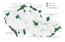
Map of protected areas of the Czech Republic: national parks (grey) and protected landscape areas (green) There are several types of protected areas of the Czech Republic. The main form of landscape protection is delimitation of special protected areas. All the types of protected areas are determined by law. (Full article...)
Protected areas may also be protected for their value and importance as historical, cultural heritage or scientific sites. More information on these can be found in the list of heritage sites in South Africa. (Full article...)
The mountain of Stob Binnein lies in the Loch Lomond and The Trossachs National Park. Many parts of Scotland are protected in accordance with a number of national and international designations because of their environmental, historical or cultural value. Protected areas can be divided according to the type of resource which each seeks to protect. NatureScot has various roles in the delivery of many environmental designations in Scotland, i.e. those aimed at protecting flora and fauna, scenic qualities and geological features. Historic Environment Scotland is responsible for designations that protect sites of historic and cultural importance. Some international designations, such as World Heritage Sites, can cover both categories of site.
The various designations overlap considerably with many protected areas being covered by multiple designations with different boundaries. (Full article...)
Image 12
A National Biodiversity Conservation Area (NBCA) is an environmentally protected area in Laos. There are all together 21 different NBCAs in Laos, protecting 29,775 square kilometers. Another 10 NBCAs have been proposed, many of them being treated by authorities as though they were already officially protected. (Full article...)
Image 13
Kentucky's system of 44 state parks has been referred to as "the nation's finest" and experiences more repeat business annually than those of any other U.S. state. The state's diverse geography provides a variety of environments to experience. From mountain lakes to expansive caves to forests teeming with wildlife, park-goers have their choice of attractions, and they are all within a day's drive of each other.
Unless otherwise specified, data in the following lists are taken from Kentucky State Parks by Bill Bailey. (Full article...)
This is a list of protected areas of Yukon. The Yukon, formerly called Yukon Territory and sometimes referred to as just Yukon is the smallest and westernmost of Canada's three territories. It also is the least populated province or territory in Canada, with a population of 35,874 people as of the 2016 Census. (Full article...)
Image 6Only a few of the largest large igneous provinces appear (coloured dark purple) on this geological map, which depicts crustal geologic provinces as seen in seismic refraction data


.png)

 Earth's night-side upper atmosphere appearing from the bottom as bands of afterglow illuminating the troposphere in orange with silhouettes of clouds, and the stratosphere in white and blue. Next the mesosphere (pink area) extends to the orange and faintly green line of the lowest airglow, at about one hundred kilometers at the edge of space and the lower edge of the thermosphere (invisible). Continuing with green and red bands of aurorae stretching over several hundred kilometers. (from Earth)
 A 2012 artistic impression of the early Solar System's protoplanetary disk from which Earth and other Solar System bodies were formed (from Earth)
 Artist's impression of a Hadean landscape with the relatively newly formed Moon still looming closely over Earth and both bodies sustaining strong volcanism. (from History of Earth)
 Standing Buddha from Gandhara, 2nd century CE
 A reconstruction of human history based on fossil data. (from History of Earth)
 Lithified stromatolites on the shores of Lake Thetis, Western Australia. Archean stromatolites are the first direct fossil traces of life on Earth. (from History of Earth)
 Artist's impression of Earth during the later Archean, the largely cooled planetary crust and water-rich barren surface, marked by volcanoes and continents, features already round microbialites. The Moon, still orbiting Earth much closer than today and still dominating Earth's sky, produced strong tides. (from History of Earth)
 A view of Earth with its global ocean and cloud cover, which dominate Earth's surface and hydrosphere; at Earth's polar regions, its hydrosphere forms larger areas of ice cover. (from Earth)
 An artist's impression of ice age Earth at glacial maximum. (from History of Earth)
 The replicator in virtually all known life is deoxyribonucleic acid. DNA is far more complex than the original replicator and its replication systems are highly elaborate. (from History of Earth)
 Tiktaalik, a fish with limb-like fins and a predecessor of tetrapods. Reconstruction from fossils about 375 million years old. (from History of Earth)
 Chloroplasts in the cells of a moss (from History of Earth)
 Trilobites first appeared during the Cambrian period and were among the most widespread and diverse groups of Paleozoic organisms. (from History of Earth)
 The pale orange dot, an artist's impression of the early Earth which might have appeared orange through its hazy methane rich prebiotic second atmosphere. Earth's atmosphere at this stage was somewhat comparable to today's atmosphere of Titan. (from History of Earth)
 Cross-section through a liposome (from History of Earth)
 Last Moon landing: Apollo 17 (1972)
 A reconstruction of Pannotia (550 Ma). (from History of Earth)
 A 580 million year old fossil of Spriggina floundensi, an animal from the Ediacaran period. Such life forms could have been ancestors to the many new forms that originated in the Cambrian Explosion. (from History of Earth)
 Machu Picchu, Inca Empire, Peru
 Change in average surface air temperature and drivers for that change. Human activity has caused increased temperatures, with natural forces adding some variability. (from Earth)
 Geologic map of North America, color-coded by age. From most recent to oldest, age is indicated by yellow, green, blue, and red. The reds and pinks indicate rock from the Archean.
 An animation of the changing density of productive vegetation on land (low in brown; heavy in dark green) and phytoplankton at the ocean surface (low in purple; high in yellow) (from Earth)


 Persepolis, Achaemenid Empire, 6th century BCE
 An artist's rendering of a protoplanetary disk (from History of Earth)

 Benin Bronze head from Nigeria
 Japanese depiction of a Portuguese carrack. European maritime innovations led to proto-globalization.
 First airplane, the Wright Flyer, flew on 17 December 1903.
 A pillar at Göbekli Tepe
 Artist's conception of Hadean Eon Earth, when it was much hotter and inhospitable to all forms of life. (from History of Earth)
 Dinosaurs were the dominant terrestrial vertebrates throughout most of the Mesozoic (from History of Earth)
 Earth's history with time-spans of the eons to scale (from History of Earth)
 Tracy Caldwell Dyson, a NASA astronaut, observing Earth from the Cupola module at the International Space Station on 11 September 2010 (from Earth)
 Satellite time lapse imagery of Earth's rotation showing axis tilt (from Earth)
 A composite image of Earth, with its different types of surface discernible: Earth's surface dominating Ocean (blue), Africa with lush (green) to dry (brown) land and Earth's polar ice in the form of Antarctic sea ice (grey) covering the Antarctic or Southern Ocean and the Antarctic ice sheet (white) covering Antarctica. (from Earth)
 Earth's axial tilt causing different angles of seasonal illumination at different orbital positions around the Sun (from Earth)
 Great Mosque of Kairouan, Tunisia, founded 670 CE
 Empires of the world in 1898
 Olmec colossal head, now at the Museo de Antropología de Xalapa
 Obelisk of Axum, Ethiopia
 Ming dynasty section, Great Wall of China
 Notre-Dame de Paris, France
 A schematic view of Earth's magnetosphere with solar wind flowing from left to right (from Earth)
 A banded iron formation from the 3.15 Ga Moodies Group, Barberton Greenstone Belt, South Africa. Red layers represent the times when oxygen was available; gray layers were formed in anoxic circumstances. (from History of Earth)
 Taj Mahal, Mughal Empire, India
 Great Pyramids of Giza, Egypt
 Artist's rendition of an oxinated fully-frozen Snowball Earth with no remaining liquid surface water. (from History of Earth)
 Chennakesava Temple, Belur, India
 A computer-generated image mapping the prevalence of artificial satellites and space debris around Earth in geosynchronous and low Earth orbit (from Earth)
 Earth's land use for human agriculture in 2019 (from Earth)
 Artist's impression of the enormous collision that probably formed the Moon (from History of Earth)
 Artist's conception of Devonian flora (from History of Earth)
 "Lucy", the first Australopithecus afarensis skeleton found, was only 1.06 m (3 ft 6 in) tall.
 Battle during the 1281 Mongol invasion of Japan
 A map of heat flow from Earth's interior to the surface of Earth's crust, mostly along the oceanic ridges (from Earth)
 Yggdrasil, an attempt to reconstruct the Norse world tree which connects the heavens, the world, and the underworld. (from World)
 View of Earth from the Moon by the Lunar Reconnaissance Orbiter (from Earth)
 A composite image of artificial light emissions at night on a map of Earth (from Earth)
 A view of Earth with different layers of its atmosphere visible: the troposphere with its clouds casting shadows, a band of stratospheric blue sky at the horizon, and a line of green airglow of the lower thermosphere around an altitude of 100 km, at the edge of space (from Earth)
 Image of the physical world, captured by the Hubble Space Telescope (from World)
 Florence, birthplace of the Italian Renaissance
 Earth's western hemisphere showing topography relative to Earth's center instead of to mean sea level, as in common topographic maps (from Earth)
 Vitruvian Man by Leonardo da Vinci epitomizes the advances in art and science seen during the Renaissance. (from History of Earth)
 Angkor Wat temple complex, Cambodia, early 12th century
 Pangaea was a supercontinent that existed from about 300 to 180 Ma. The outlines of the modern continents and other landmasses are indicated on this map. (from History of Earth)
 Graph showing range of estimated partial pressure of atmospheric oxygen through geologic time (from History of Earth)
 Shanghai. China urbanized rapidly in the 21st century.
 Fall of the Berlin Wall, 1989
 Peopling of the world, the Southern Dispersal scenario
 Ajloun Castle, Jordan


.jpeg)


.jpg)


.svg)


.jpg)


.jpg)


 Time zones of the world
 Index map from the International Map of the World (1:1,000,000 scale)
 United Nations Human Development Index map by country (2016)
 The Goode homolosine projection is a pseudocylindrical, equal-area, composite map projection used for world maps.
 1516 map of the world by Martin Waldseemüller
 Only a few of the largest large igneous provinces appear (coloured dark purple) on this geological map, which depicts crustal geologic provinces as seen in seismic refraction data
 The world map by Gerardus Mercator (1569), the first map in the well-known Mercator projection
 Mollweide projection of the world
 A plate tectonics map with volcano locations indicated with red circles


 Commons
 Wikibooks
 Wikidata
 Wikinews
 Wikiquote
 Wikisource
 Wikispecies
 Wikiversity
 Wikivoyage
 Wiktionary


